February 15, 2010
Big Bend Trip
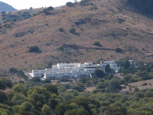
Fort Davis State Park
Today we drove from Austin south to Fort Davis State Park, about 7 hours. We are on the first leg of the Big Bend Trip. The scenery is really amazing here, the park is a mile above sea-level and has spectacular mountain vistas and is surrounded by the Chihuahuan Desert. The scenery is just as mythic Texan I had imagined. We even saw a real cowboy riding out on the range from our speeding car.
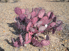
The larger rainfall and cooler temperatures in the mountains encourages the growth of oaks, junipers and grasses. The exposed igneous rock of the canyons walls were formed by volcanic activity over 23 millions years ago. Along the Limpia and Keesey Creeks grow cottonwood, willows, Emory oaks and gray oaks. Some of the native animals are tree frogs, black-tailed rattlesnakes, Montezuma quail and mountain lions.
In the park we drove around Skyline Drive to check out all the various views. I took plenty of pictures of the fauna and well as the views. The photos do not match how great the vistas are. We went to check out the bird watching spot to see if we could observe the Montezuma quails. There were about 10 other bird enthusiasts but no quail. We did see plenty of rock doves, canyon towhees (3), American goldfinches (6) and pine siskins (4).
We are staying in the historic Indian Lodge located in Fort Davis State Park. The CCC developed it and the park between 1933 and 1935. Architect Bill Caldwell designed the Lodge to be reminiscent of pueblos in New Mexico. Workers utilized old adobe construction techniques of molding earthen bricks from a mixture of water, straw and soil. Our large comfortable room is on an upper level and has fantastic views of the mountains. We went out to see the abundant stars and I am looking forward to seeing the sun rise tomorrow morning.
February 16, 2010
We hiked around a bit in the Davis Mountains and had dinner at the Limpia Hotel Resturant. In the evening we attended the Star Party at the MacDonald Observatory. It was a cold night but it was really informative. First there is a night sky show followed by the opportunity to see different costellations in the Observatory telescopes.
February 17, 2010
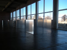
We traveled onto to Marfa and then Alpine (where we spent the night). In 1971, Donald Judd, minimalist artist, moved to Marfa from New York City. He bought two large hangars, some smaller buildings and started to permanently install his art. Judd's vision was to house large collections of individual artists' work on permanent display, as a sort of anti-museum. Judd believed that the prevailing model of a museum, where art is shown for short periods of time, does not allow the viewer an understanding of the artist or their work as they intended.
Since Judd's death in 1994, two foundations have been working to maintain his legacy: the Chinati Foundation and Judd Foundation. Every year The Chinati Foundation holds an Open House event where artists, collectors, and enthusiasts come from around the world to see art.
In Marfa we went on the Chinati Foundation tour of Donald Judd’s work and compound. The buildings that Judd remodeled to stage his work were very impressive. But honestly, Judd’s obsessive box pieces are mind numbing to me. I do appreciate them a bit more now that I have seen the works at Marfa but nonetheless I am not really moved by it. The town of Marfa is full of young ultra-hipsters artists types whom seemed too chic and imported. A man wearing a cowboy hat who was an actual native tipped his hat to me, exchanged pleasantries, thank goodness.
In Alpine we stayed at the Alpine Lofts which were really beautifully decorated in Texas downhome style, very comfortable with loads of creature comforts. Alpine was quite different from Marfa, more authentic small town feel. We drove around to see some sights, the base ball field, the University, etc. Then we walked around the downtown, nice.
February 18 and 19, 2010
Big Bend National Park.
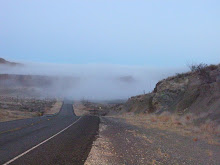
The first day we drove through the park checking out the different sites. Visited one canyon, stopped at the Rio Grande River, took pictures. The place is huge. We were told at the gate not to buy souvenirs from the Mexican natives who come across the river to sell items. Along many of the various pathways to sites there are items placed with simple signs listing prices of items and a jar for cash. I didn’t buy anything and I now regret not putting money in the jars. Locals talked about how the Mexican villages across the river once thrived from the American tourists who would come to the town and buy things. Now US border restrictions have cut off this sort of trade. One canyon we visited had a singing Mexican cowboy on the other side. He was pretty good and had a tip jar on our side, I did give him some money, I wish I had had more, hearing him sing was pretty beautiful. I did film him.
February 16, 2010
We hiked around a bit in the Davis Mountains and had dinner at the Limpia Hotel Resturant. In the evening we attended the Star Party at the MacDonald Observatory. It was a cold night but it was really informative. First there is a night sky show followed by the opportunity to see different costellations in the Observatory telescopes.
February 17, 2010
We traveled onto to Marfa and then Alpine (where we spent the night). In 1971, Donald Judd, minimalist artist, moved to Marfa from New York City. He bought two large hangars, some smaller buildings and started to permanently install his art. Judd's vision was to house large collections of individual artists' work on permanent display, as a sort of anti-museum. Judd believed that the prevailing model of a museum, where art is shown for short periods of time, does not allow the viewer an understanding of the artist or their work as they intended.
Since Judd's death in 1994, two foundations have been working to maintain his legacy: the Chinati Foundation and Judd Foundation. Every year The Chinati Foundation holds an Open House event where artists, collectors, and enthusiasts come from around the world to see art.
In Marfa we went on the Chinati Foundation tour of Donald Judd’s work and compound. The buildings that Judd remodeled to stage his work were very impressive. But honestly, Judd’s obsessive box pieces are mind numbing to me. I do appreciate them a bit more now that I have seen the works at Marfa but nonetheless I am not really moved by it. The town of Marfa is full of young ultra-hipsters artists types whom seemed too chic and imported. A man wearing a cowboy hat who was an actual native tipped his hat to me, exchanged pleasantries, thank goodness.
In Alpine we stayed at the Alpine Lofts which were really beautifully decorated in Texas downhome style, very comfortable with loads of creature comforts. Alpine was quite different from Marfa, more authentic small town feel. We drove around to see some sights, the base ball field, the University, etc. Then we walked around the downtown, nice.
February 18 and 19, 2010
Big Bend National Park.
The first day we drove through the park checking out the different sites. Visited one canyon, stopped at the Rio Grande River, took pictures. The place is huge. We were told at the gate not to buy souvenirs from the Mexican natives who come across the river to sell items. Along many of the various pathways to sites there are items placed with simple signs listing prices of items and a jar for cash. I didn’t buy anything and I now regret not putting money in the jars. Locals talked about how the Mexican villages across the river once thrived from the American tourists who would come to the town and buy things. Now US border restrictions have cut off this sort of trade. One canyon we visited had a singing Mexican cowboy on the other side. He was pretty good and had a tip jar on our side, I did give him some money, I wish I had had more, hearing him sing was pretty beautiful. I did film him.
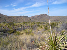
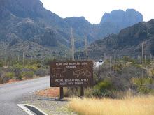
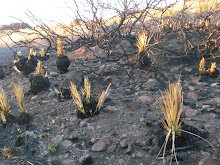
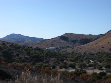
The dominant feature of Big Bend National Park is the Rio Grande River, and three major canyons fall within the park boundary; Santa Elena, Marsical and Boquillas, between which the river flows through desert land that is wild and mostly unreachable. North of the Rio Grande the park is mostly arid and rocky with only limited access by paved roads, a part of the great Chihuahuan Desert, which extends across much of north Mexico into Texas. Plant life is particularly varied and plentiful, with over 60 species of cacti plus other spiky plants. Landscape features include narrow canyons, colorful eroded badlands, sand dunes and desert oases.
A prominent exception is Chisos Mountains, a range of cliffs and peaks rising to 7,825 feet in the center of the park. In these tree-covered slopes the hot desert seems far away and many trails give access to a cool, sheltered world, inhabitants of which include black bears and mountain lions.
We visited the following:
Southeast: a region of empty desert, with two large canyons along the Rio Grande
• Hot Springs Trail - 4 mile path along the river to historic springs
Southwest: a region of empty desert, with two large canyons along the Rio Grande
• Hot Springs Trail - 4 mile path along the river to historic springs
Chisos Mountains: dramatic mountain range at the centre of the park


No comments:
Post a Comment